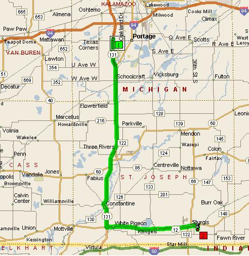
Directions to Sturgis High School (909 S. Franks Ave, Sturgis)
1. Get on US-131 south by any means accounting for current construction and Oakland Dr and US-131/I94.
2. Continue south on US-131 through Constantine (remember the left turn and jog right in Constantine) to US-12 and turn left on US-12.
3. Continue east on US-12 through While Pigeon and continue 13 miles to Sturgis.
4. On the far side of Sturgis, turn right on Franks and the high school is a short distance south on the right (west) side of the street. Note some sources say the high school is at 216 Vinewood which is a big block west of Franks..
Driving Time about 1 hr from PNHS (49 miles)

Note- some mapping programs recommend taking US-131 to CR-120 (Michigan Ave) and going through Mendon via Silver St (CR-133) and CR-60 to CR-66, which is 1 mile shorter (driving through Mendon is quicker than driving through Constantine, but there are more turns to make).
The Google Maps image shows the region around the High School and Franks and Vinewood. Click on the image below to navigate around.
